The view from the park
The mountain in front of you is older than almost everything else you will ever look at.
Stand in Hess Farms Park in Kaysville, face the mountain, and you are looking at rock that was cooked twenty miles underground before there was anything alive on land. This page works out what is actually in front of you, using the same ground survey the government uses.
The wall of mountain east of Kaysville is the Farmington Canyon Complex: banded gneiss, baked and recrystallised deep in the crust about 1,700 million years ago. Everything below is worked out from the US Geological Survey's national elevation model, its stream and place-name records, and the Utah Geological Survey's own map of this ground, with the curve of the Earth and the bending of light through air taken into account.
Everything on this page is worked out from one standing place: Hess Farms Park in Kaysville, 41.0080819, -111.9251271, about 4,320 feet above sea level, with the eye five and a half feet off the ground. Stand there facing the mountain and the horizon on this page is the horizon in front of you.
The mountain front, as it actually stands from the park
True proportions. A degree across is a degree up.
Six canyons, and the order matters
Six canyons notch the mountain front along this stretch. North to south they are Bair, Shepard, Farmington, Rudd, Steed and Davis. That order is worth learning, because two of them have killed people, and the two are not the two you would guess.
Six named creeks leave the range along this reach. From north to south: Bair Creek, Shepard Creek, Farmington Creek, Rudd Creek, Steed Creek, Davis Creek. Each canyon mouth below is the last point where rock still rises at least 80 ft above the creek on both sides within 250 m, that is, the last place the flow is still hemmed in before it spreads.
Deep time
Three different things tilted this rock, hundreds of millions of years apart
The grain in the mountain leans. People assume that means the rock was pushed over once. It was tilted three separate times by three unrelated events, and only the last one is still happening.
The fabric of the Farmington range front records three events laid one over another: a steep grain (foliation) set into the rock while it was still deep and hot, folding and stacking during the Sevier mountain building, and the slow backward tilt of the whole range block on the Wasatch fault. Only the third is active.
- About 1,700 million years ago. The rock was squeezed and heated deep in the crust until its minerals lined up in sheets. That grain is what you see leaning on the mountain front. It was set while the rock lay miles down, not standing up here.
- Between about 125 and 50 million years ago. Utah was being shoved eastward. Whole sheets of rock rode up and over one another for tens of miles, folding whatever lay on top.
- The last 17 million years or so, and still going. The crust started pulling apart. The valley side dropped, the mountain side rose, and the whole mountain block tipped slowly backward to the east.
- About 1,700 million years ago. Peak metamorphism of the Farmington Canyon Complex. The steep foliation formed at depth and predates every structure that now carries it.
- About 125 to 50 million years ago. Sevier mountain building. The Willard and Ogden thrust sheets carried older rock eastward over younger; a low-angle thrust is interpreted beneath Farmington from seismic and gravity surveys.
- About 17 million years ago to now. Basin and Range stretching on the west-dipping Wasatch fault. The mountain side rises and rotates backward to the east; the valley side drops and fills.
The same fault, photographed
Three pictures from the US Geological Survey. Public domain.
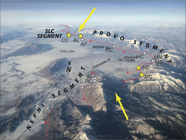
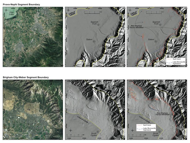
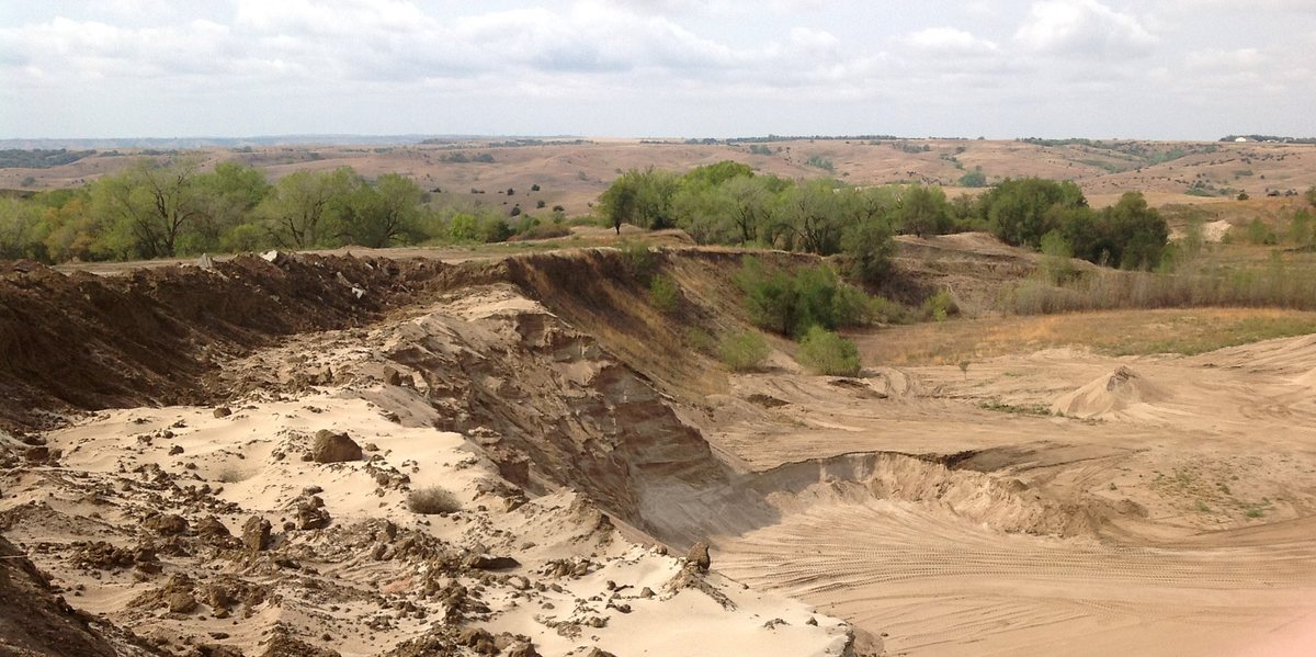
What you will not find up the canyon
Drive Farmington Canyon and you will see no layered rock at all. There is none to see. The younger layers that once lay over this ground have been stripped clean off, right down to the ancient floor beneath them. Layers only reappear when you crest the ridge and look east into Morgan Valley.
No layered Paleozoic rock is exposed anywhere on the Utah Geological Survey's map of the Farmington area. Its legend runs from the young loose surface material straight to the 1,700-million-year-old gneiss, with nothing in between. The mountain side of the fault is stripped to basement. primary
The grey banded rock
Most of the mountain front. Grey, streaked light and dark in tight bands that lean steeply. Quartz, feldspar and dark flaky minerals with garnets, shot through with veins and smeared zones. It forms the rubble-strewn cliffs along Farmington Canyon.
The pale coarse-veined rock
Lighter, with big crystals and a weaker grain, tucked in among the grey rock south of Farmington Canyon. Greenish where water has worked on it.
Under the valley floor
The valley side of the fault has sunk and filled: up to 8,000 ft of old valley fill, then 1,300 ft laid down through the ice ages, then the lake mud and canyon gravel of the last 11,000 years that the towns stand on.
Rock descriptions and fill thicknesses from the Utah Geological Survey's geologic map of the Farmington area, which labels the two rock types Xfcg and Xfcm. primary
The lake
Your street was under 900 feet of water
Lake Bonneville filled this valley to a level well above the roof of the highest house on the bench. The flat steps you drive along, the ones the older streets follow, are its beaches.
At its fullest, Lake Bonneville's shoreline across the Farmington area lies at 5,180 to 5,200 ft. The terraces that carry the older street grid are the beaches it cut on the way back down, the widest of them at the Provo level. The elevations below are the ones mapped on this ground, not regional averages.
The shorelines, measured here rather than in general
Published figures for the top shoreline range from about 5,090 to 5,220 ft depending on where you stand, because the ground under the middle of the old lake sagged more under the weight of the water and rose back further once it left. A local claim needs a local number. These are the heights mapped on the Farmington ground itself.
| Shoreline | Height, ft | Raw carbon-dating count, years | Actual calendar years ago |
|---|---|---|---|
| Stansbury | 4,440 to 4,450, but not traceable here | 22,000 to 20,000 | 26,000 to 24,000 |
| Bonneville, the top | 5,180 to 5,200 | 15,200 to 15,000 | 18,500 to 18,000 |
| Provo | 4,820 to 4,860 | 15,000 to 12,600 | 18,000 to 15,000 |
| Beaches cut on the way down | 4,380 to 4,820 | 12,600 to 11,500 | 15,000 to 13,000 |
| Gilbert | about 4,250 | 10,000 | 11,500 |
| Great Salt Lake, high point of the last 5,000 years | 4,217 to 4,221 | 4,200 to 2,100 | 5,000 to 2,000 |
| Great Salt Lake, highest in written records | 4,212 | late 1860s and 1986 to 87 | - |
Utah Geological Survey, geologic map of the Farmington area (Map 279DM), second sheet, table 2, the shoreline height table for this ground. primary
Two things almost everybody gets wrong
The figure "14,500 years ago" for the great Bonneville flood is a raw carbon-dating count, not a calendar age. The two right-hand columns of the table above are the same event measured two ways: the raw count, and the real calendar years it converts to. The lake stood at its fullest about 18,000 to 18,500 years ago.
Sources still disagree on the exact date of the flood. The disagreement is shown here rather than settled.
The Stansbury shoreline is lower than the Bonneville shoreline, so it looks like the next step down. It is not. It was cut on the way up, roughly 6,000 years before the lake reached its top. And on this ground it is too faint to trace at all, which is why no Stansbury line is marked on the mountain front in the view above.
The canyon
From the canyon mouth to the radar domes, in twelve and a half miles
Farmington Canyon is the odd one out. It gathers rain and snowmelt from four times as much mountain as any of its neighbours, which is why it has a creek that runs all year while the others dry up.
Farmington Creek gathers water from 10.58 square miles of mountain, against 0.66 to 3.34 for the other five, and rises at Farmington Flats above 8,000 ft. It is the only one of the six that flows year round. The mapped road from the canyon mouth to Francis Peak measures 12.71 miles and climbs 5,017 ft. measured
The fans
The towns are built on the evidence
Below every canyon mouth the ground spreads out in a low, gently sloping apron, the shape of a hand fan laid flat. Every one of these neighbourhoods sits on one. The fan is not scenery. It is the pile left by the last few thousand slides of rock and mud out of the canyon behind it, and it is there because that is where they stop.
The bench between the mountain front and the lake flats is a row of fans that have grown into one another, each an apron of rock and mud spread out from a canyon mouth over the last 20,000 years. The fan is the landform made by the very process that threatens it.
Why a debris flow is not a flood
A flood is water carrying some dirt. A debris flow is dirt carrying some water, at the consistency of wet concrete. It arrives in surges, each one led by a snout of boulders and whole trees, and the boulders ride on top rather than rolling along the bottom. You hear it before you see it: a low grinding rumble.
Debris flows here run 60 to 90 percent solids by weight and move as a stiff slurry rather than as water. They come as a train of surges; each surge builds a snout of boulders and trees at its front as the big pieces work forward and upward, and that snout carries the momentum. In a steep, walled-in channel they typically travel 10 to 35 mph.
The walls are the whole story
The same 1923 flow was reported 75 to 100 ft deep inside Farmington Canyon, filled houses on the fan with up to 13 ft of mud, left up to 6 ft on the highway, and put 3 ft of water across Lagoon. Those four numbers are four different things measured four different ways, and the direction is the point: deep and narrow between the canyon walls, thin and wide once it is out on the open fan. Lose the walls and you lose the depth; lose the depth and you lose the push; a debris flow needs a certain push to keep moving at all, so it simply stops.
| Where | Figure | What it is a measure of | Confidence |
|---|---|---|---|
| Between the canyon walls | 75 to 100 ft | how deep the flow ran, probably read from a mud line | contested |
| Inside Farmington homes | up to 13 ft | how thick the mud was left | unverified |
| Highway, Willard and Farmington | up to 6 ft | how thick the mud was left | unverified |
| Lagoon | 3 ft | how deep the standing water was | unverified |
The three events
13 August 1923
Cloudburst on slopes stripped bare by grazing and fire. Farmington and Willard both hit. The dead in Farmington Canyon were people camped in the creek bed at night. unverified
Late May to early June 1983
Fast snowmelt in an El Nino year sent about 90,000 cubic yards out of Rudd Creek onto the fan. Rudd gathers from the smallest and steepest patch of mountain of the six. unverified
6 April 2004
Thunderstorms on ground burned in the July 2003 Farmington fire. The damage came from small unnamed gullies with nothing built to catch them. unverified
Two of the three followed fire or unusual snowmelt rather than record rainfall. What decides it is the state of the mountainside above the town, not the size of the storm.
The engineering
What is actually built, and what it can and cannot do
After 1923 the response was to change the mountain: thousands of level trenches dug across the slope so rain could never gather into a torrent. After 1983 the response was to change the bottom: catch basins at the canyon mouths to hold what comes down. Both work. Neither is a promise.
Two generations of defence: 1930s contour trenching of the slopes, meant to stop rain from gathering into channels, and post-1983 catch basins at the top of each fan, meant to hold the volume of rock and mud a design storm would bring down.
Farmington Pond
The pond sits about 360 m below the Farmington Canyon mouth, on Farmington Creek, right at the top of the fan where the canyon opens out. That is exactly where a catch basin goes. measured
No separate basin above the pond appears on the national map of streams and ponds, and nothing else on Farmington Creek between the canyon mouth and the pond is mapped as water. That fits the pond itself being the flood-control structure on this creek.
But it rests partly on absence, and absence is weak. A dry catch basin need not appear on a map of water at all, so this check cannot rule one out. Settling it needs Davis County Public Works or the county's own construction drawings.
A pond that doubles as a catch basin is compromised for reasons that have nothing to do with how well it was built: the water already in it takes up room the mud would otherwise use; how much mud is already down there cannot be seen; cleaning it out means draining it first and handling sodden spoil; and an arriving debris flow shoves the pond ahead of itself, so a wave of water reaches the houses before the mud does. reasoning
The gap in the rules
Whatever the rules say, they only reach forward. Most of this fan was divided up and built on before any of them existed. The homes the 1983 flow hit were legally permitted under the rules of their day. reasoning
The air
The same bowl that holds the towns holds the cold
In winter the air here turns upside down: cold at the bottom, warm on top. Once that happens the air stops mixing, and everything put into it stays in it. The container doing the trapping is the valley the fault made and the lake filled.
A pool of cold air settles into the tilted trough of the valley and stays for days: it forms as the ground radiates heat away on clear nights, as cold air slides down off the slopes, and as snow cover reflects the daytime sun, and it is held in place by warmer air sinking and settling over the top under a ridge of high pressure. Layered cold under warm is stable, so the column stops mixing.
Note the direction carefully, because even published summaries get it backwards. Normally the air gets colder as you go up, about 3.5 degrees for every 1,000 ft. In an inversion it gets warmer as you go up. Cold below, warm above. A pocket of air nudged upward finds itself colder and heavier than its surroundings and sinks straight back.
The tie to the ground is the part that is solid. The bowl holding the cold air is the same sunken trough the Wasatch fault let drop, and the same bowl Lake Bonneville filled. The fault built the container. reasoning on primary geology
Sources
What each claim rests on
Markers appear next to claims throughout the page. They mean what they say, and the least flattering ones are used the most, on purpose.
- primary read directly from an agency publication, statute, survey or peer-reviewed paper
- secondary a reputable account, or a primary source read through a summary
- measured worked out here from a public survey, with the method named
- contested sources disagree and both sides are shown
- reasoning a conclusion drawn here rather than a reported fact
- unverified carried from the research draft and not yet confirmed
Where the numbers come from
- The national elevation survey (USGS 3DEP, about 10 m spacing)
- The skyline, every height, every canyon mouth, the shaded map of the slopes. Fetched once and checked at twelve random spots against the USGS's own point lookup; the worst disagreement was 5 ft.
- The national map of streams and ponds (USGS National Hydrography Dataset)
- Where each named creek actually runs. Settled the north-to-south order of the canyons, which the place-name register could not.
- The official place-name register (USGS GNIS, Utah)
- Names, official spellings and naming decisions. Bair Canyon, not Baer; Rudd Creek, and no Rudd Canyon.
- Utah Geological Survey, geologic map of the Farmington area (Map 279DM)
- The rock types, the shoreline height table, how deep the valley is filled, and the earthquake-shaken ground west of Farmington.
- Utah Geological Survey, surface geology of part of the Kaysville area (Map 224)
- The second, independent local measurement of the Provo shoreline.
- Utah Geological Survey, active fault map
- The line of the Wasatch fault along the foot of the mountains, traced in the view above exactly where the survey maps it.
- US Geological Survey, Earthquake Hazards Program, Wasatch fault pages
- The three photographs in the deep-time section, and what their captions say about segments, laser surveys and trenches. Federal work, public domain, fetched 2026-09-04 and served from here.
- US Census Bureau address lookup
- Turned the street address into a map position. A street address is not a survey mark, and the page says so where it matters.
The full ledger
Every claim on this site has a row in RESEARCH.md in the
source folder, with its status, its source, the type of source, and the
date it was checked. That file also records the corrections this build
made to the research it started from, including the shoreline heights,
the position of Francis Peak, and a mistake in reading the elevation
survey that would have put the ground 456 ft too high.